 |
Trees, Woods, Forests
Speed's Hampshire 1611 |
|
 |
click for feature map
|
| Trees |
Woods and forests, on Speed's map of Hampshire, are shown by
drawings of trees. They appear to be grouped meaningfully,
either in parks, or in groups for a wood or forest, which might
be labelled, eg:- Beare Forest, Limwood. There
are no tree symbols in the north of the county, except in parks.
There are some forests without any trees, but labelled,
eg:- Buckholt Forrest, West Forrest.
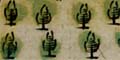
there are two styles of tree symbol.
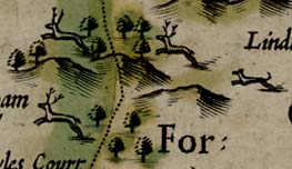
In the New Forest there is a splendid group of deer leaping
through trees and hills, chased by a hound.
|
|
| forests |
BEWARE: to get back to this list after clicking on an item,
use the back button.
'modern' name (parish; ngr) = old name (hundred) if given |
 |
Buckholt Forest
= Buckholt Forrest (Thornegate Hundred)
|
|
|
Chute Forest
= Chure Forrest (Andover without Hundred)
|
|
|
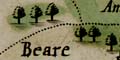
East Bere Forest?
= Beare Forest (Portesdowne Hundred)
|
|
|
Linwood Coppice (Bramshaw parish; SU2414)
= Limwood (Newforrest Hundred)
|
|
|
New Forest
= Newe Forrest (Rinwood Hundred)
|
|
|
West Bere Forest
= West Forrest (Budlesgate Hundred)
|
|
Notice that, copying from Norden 1607, the 'Beare' belonging to
West Bere Forest is engraved as part of the name of
Weeke, 'Beareweek'.
|


