 |
Parks
Speed's Hampshire 1611 |
|
 |
click for feature map
|
| Parks |
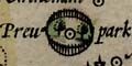
Parks on Speed's map of Hampshire, are shewn by a ring of paling
fence. This might enclose a group of trees, and perhaps a symbol
for a settlement of some sort. Most of the parks are just ovals;
Titchfield has a double ring. At least one park is labelled:-
Preu park, but others are only named by implication from
the enclosed settlement name - the settlement may be just the
park house.
Making a park, the formal procedure of emparkment, is a privelege
granted by the Crown. Many of the parks shown on early maps were
emparked in the 12th-14th centuries. Parks on Speed's map are
listed below.
Parks, where possible, have been identified with a location, mostly
a park, on a modern map. The modern park name is a label to
identify the location and may not exist as a current place name. |
|
| parks |
BEWARE: to get back to this list after clicking on an item,
use the back button.
'modern' name (parish; ngr) = old name (hundred) if given
|
 |
park
|
|
|
Beaurepaire Park (Sherborne St John parish; SU6358)
= Baropey (Basingstocke Hundred)
|
|
|
Bedhampton Park (Havant parish; SU7008?)
|
|
|
Bishops Waltham Park? (Bishops Waltham parish)
|
|
|
Bramshill Park (Bramshill parish; SU7559)
|
|
|
Clare Park (Crondall parish; SU8047)
|
|
|
Compton Park (Kings Somborne parish; SU3429)
|
|
|
Dogmersfield Park? (Dogmersfield parish)
= Drogmersfeild (Odiam Hundred)
|
|
|
East Meon Park? (Eastmeon parish)
|
|
|
Elvetham Park (Hartley Wintney parish)
= Elvesham (Odiam Hundred)
|
|
|
Fareham Park (Fareham parish)
|
|
|
Farleigh Park (Farleigh Wallop parish; SU6246)
|
|
|
Freemantle Park (Hannington parish)
= Fremanton (Kingscler Hundred)
|
|
|
Grove Place Park? (Nursling and Rownhams parish; SU3616?)
= Grove place (Redbridge Hundred)
|
|
|
Hackwood Park (Winslade parish; SU6549)
|
|
|
Hale Park (Hale parish; SU1818)
|
|
|
Hambledon Park? (Hambledon parish)
|
|
|
Highclere Park (Highclere parish; SU4459)
|
|
|
Houghton Park (Houghton parish)
|
|
|
Hursley Park (Hursley parish; SU4225)
= Hursley (Budlesgate Hundred)
|
|
|
Hurstbourne Park (Hurstbourne Priors parish; SU4447)
|
|
|
Marwell Park (Owslebury parish)
= Maxwell (Fawley Hundred)
|
|
|
New Park (Brockenhurst parish)
= Parke (Newforrest Hundred)
|
|
|
New Park (Old Basing parish; SU6651)
|
|
|
Odiham Park (Odiham parish)
|
|
|
Paultons Park (Copythorne parish; SU3116)
|
|
|
Prewett Park (Sherborne St John parish; SU6153?)
= Preu park (Basingstocke Hundred)
|
|
|
Pylewell Park (Boldre parish; SZ3596)
= Parckhouse (Newforrest Hundred)
|
|
|
Rotherfield Park (East Tisted parish; SU6932)
= Votherfeild (Alton Hundred)
|
|
|
Silchester Park (Silchester parish)
= Silchester (Holdshot Hundred)
|
|
|
Southwick Park (Southwick and Widley parish)
|
|
|
Stratfield Saye Park (Stratfield Saye parish; SU7061)
|
|
|
Titchfield Park (Fareham parish; SU5307)
|
|
|
Vyne Park (Sherborne St John parish; SU6356)
= Vine, The (Basingstocke Hundred)
|
|
|
Warblington Park (Havant parish; SU7205)
|
|
|
West Park (Rockbourne parish; SU1116)
|
|
|
Worthy Park (Itchen Valley parish; SU5032)
= Martyn Worthy (Barton Stacye Hundred)
|


