Relief, Hills
Speed's Hampshire 1611
'modern' name (parish; ngr) = old name (hundred) if given

|
|
Relief, HillsSpeed's Hampshire 1611 |
|
|
click for feature map |
| Hills | John Speed uses little hillocks generally shaded on the right, to indicate the relief of Hampshire on his map. The symbols are grouped to some degree, but overall do not clearly demonstrate the bones of the county. The ridge of hils west of Winchester is clear; Portsdown is shown as a line of hillocks; and so on. |
| hills |
BEWARE: to get back to this list after clicking on an item,
use the back button. 'modern' name (parish; ngr) = old name (hundred) if given |
|
|
Butser Hill (Langrish parish; SU7120) = Butter hill (Eastmeane Hundred) |
|
|
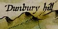
Danebury Hill (Nether Wallop parish; SU3236) = Dunbury hill (Andover without Hundred) |
  |
Speed's Hampshire 1611, contents |
|
|
feature list |
|
|
General index |
 |
Old Hampshire Mapped |