
Old Hampshire Mapped

Table of Symbols
Norden 1595of
symbols
symbol / text explanation / count of instances.
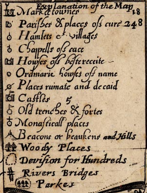
Explanation of the MapThe formal declaration of his conventional signs is an innovation in english mapmaking introduced by Norden, though used earlier in Europe. Looking closely the heading, the count numbers, and all the engraving from 'and Hill' onwards are added to what was a neater table. It is possible to see the end of the original table's cartouche. The amendments are on the earlier, Stent, state of the map, unchanged by Overton.
[dot and circle, two towers, ?weathercock] / Market townes / 18
[dot and circle, tower] / Parishes & places of cure / 248
[dot and circle, upright line] / Hamlets et villages /
[dot and circle, upright line and half bar] / Chappells of ease /
[dot and circle, two towers] / Howses of besterecite /
[dot and circle] / Howses of name /
[dot and circle, crossed out by a slash] / Places ruinate and decaid /
[dot and circle, two towers, flag] / Castles / 5
[dotted circle, flag] / old trenches & fortes /
[dot and circle, cross] / Monasticall places /
[hillock, three posts] / Beacons or beaukens and Hills /
[trees] / Woody places /
[dotted line] Devision for Hundreds /
[wiggly lines, double line] / Rivers Bridges /
[dotted ring, trees] / Parkes /
John Norden was clearly at some pains to differentiate settlements, but interpreting his intentions from the table of symbols is not easy. We do not believe that his parish symbol, [dot and circle, tower] / Parishes & places of cure, is meant to plot a parish, an area, we think it plots a village which has the status of being a parish, has the parish church. This sort of dual thinking is still common today. The chapel of ease symbol seems more likely to indicate a hamlet that has the care of a chapel; or where there really that many little chapels all over the county - our knowledge of elizabethan society is lacking. A house of best reception symbol can often be matched to a great house, not necessarily still standing. But how much is the place just a house, and how much does the symbol also represent a settlement of dependent dwellings round about. This is even more likely to be the case with an ordinary house, the place marked is a hamlet. We are not attempting to answer these questions in Old Hampshire Mapped: the data is made available, the user can continue where we have left off.
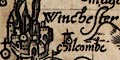
Winchester
lymington
Southampton
Odyam
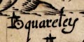
quareley
Exton
blackwaterOther settlements have variations on the line on the dot and circle, all explained in the table of symbols.
hyth