
Old Hampshire Mapped
Prime Meridian
BEWARE: the notes that follow are based on a variety of secondary sources, which I have had to take on trust.
ground
At the edge of Epping Forest there is the Chingford Pillar, an obelisk marking the Bradley meridian, set up 1824. It has a plaque indicating another obelisk 5.79 metres east, for the Airy meridian. There are other Bradley markers in England; and more recent Airy markers.
2nd century
... Hence the length of the known earth, that is, from the meridian drawn through or terminated by the Fortunate Islands in the extreme west, to Sera in the extreme east is 177 degrees 15 minutes.The Fortunate Islands are the Canaries. Ptolemy lists Venta, which is Winchester, at longitude:-
18° 40' E
It is desirable that all the nations of Europe, in place of arranging geographical longitude from their own observatories, should agree to compute it from the same meridian, one indicated by nature herself, in order to determine it for all time to come.Good idea, but there is no natural prime meridian. Piazzi Smyth 1870s: in an ironic response to some argument about the prime meridian the Astronomer Royal for Scotland suggested the Great Pyramid in Egypt.
The FIRST MERIDIAN is that from which geographers begin to count the longitude of places. On English maps and globes the first meridian is a semicircle supposed to pass through London, or the royal observatory at Greenwich. Foreigners count the longitude from the observatories of their respective nations.
The longitude of a place is the number of degrees (reckoned upon the equator) that the meridian of the said place is distant from the meridian of any other place from which we reckon, either eastward or westward, for 180 degrees, or half round the globe. The English reckon the longitude from the meridian of London, and the French now reckon it from the meridian of Paris. The meridian of that place, from which the longitude is reckoned, is called the first meridian.
'What's the good of Mercator's North Poles and Equators,from the Hunting of the Snark.
Tropics, Zones and Meridian Lines?'
So the Bellman would cry: and the crew would reply
'They are only conventional signs!'
present
Rhodes on the Island of Rhodes is about
28°2' E
The Canaries are centred:-
16° 0.0' W
The western edge of Ferro, Ile de Fer or Hierro, is about:-
18° 10' W
In a cartouche on the globe he published in 1622, John Blaeu said:-
... But in our days a good many think this starting point ought to be based on nature itself, and have taken the direction of the magentic needle as their guide and placed the prime meridian where that points true north. But that these are under a delusion is proved ... for itself [the needle] varies along the same meridian according as it is near one land mass or another ... ... following in the steps of Ptolemy, have chosen the same islands and in them Juno, commonly called Tenerife, whose lofty and steep summit covered with perpetual cloud, called by the natives El Pico, shall mark the prime meridian. In that way we have differed barely a quarter of a degree from the longitude of the Arabs who chose the extreme western shore of Africa [Cape Verde], and I thought it well to point this out.El pico is about:-
16° 45' W
The islands were used by various early cartographers.
Cardinal Richelieu convened a meeting of mathematicians and astronomers in Europe, 1634, to consider a prime meridian to be recognised by all nations. They chose the westernmost coast of the westernmost island, Ferro, in the Canaries. Louis XIII decreed, 1634:-
... In order that this first meridian may be more clearly known than it has for some time been, the Admiral of France has consulted persons of knowledge and experience in navigation. The King in consequence forbids all pilots, hydrographers, designers or engravers of maps or terrestrial globes to innovate or vary from the ancient meridian passing through the most westerly of the Canary Islands, without regard to the novel ideas of those who recently fixed it in the Azores on the supposition that there the compass does not vary, for it is certain that this happens also in other places that have never been taken for the meridian.
Determinations by Louis Feuillee from the Paris Academy, 1724, published 1742, gave Paris to be 20° 02' E and London, St Paul's 17° 37.5' E, from this meridian.
St Michael's Island was used by John Davis, 1594; because he [mistakenly] thought there was no compass deviation at that place.
The islands are the western edge of Europe; they are part of Portugal.
The Azores centred about:-
28° W
their western edge is about:-
31° W
24° 25' W
5° 12.3' W
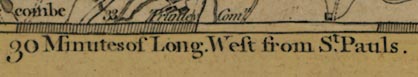
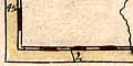
... Long. West from St. Pauls.The map shows the greenwich observatory:-
Measuring off the longitude scales - notice that the meridians slant across the map, and are at 2 minute intervals - Greenwich is 0d 5m 53s E; ie St Paul's is about:-
0° 5' 5" W of Greenwich
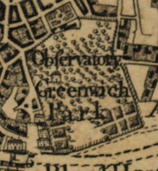
St Paul's was used to define the prime meridian by General Roy, 1790, just before the Ordnance Survey was founded, 1791.
Flamsteed
Halley
The precise position of the meridian is determined by the exact position of a transit telescope. New instrument; new meridian.
Bradley
When the Nautical Almamac began, 1767, it made the use of this meridian international. The first series of charts to use the Greenwich meridian systematically was the Atlantic Neptune, of the east coast of America, by J F W DesBarres, published 1784.
This meridian is still used for OS map making in Britain. It is 5.79 metres W of the international Prime Meridian. On everyday maps this is less than a pencil line difference
Airy
Greenwich Meridian
The Greenwich Meridian (Airy) was chosen for international use at the International Meridian Conference, Washington, United States, 22 October 1884.25 nations were present; Greenwich won the honour by 22 votes to 1; San Domingo against; 2 abstaining, France and Brazil.
Resolved:By this date the USA had already decided on Greenwich for its time zone system; and british Admiralty Charts, using Greenwich, were in predominant use in the world's commerce. Countries not at the conference have since adopted the convention.
I. That it is the opinion of this Congress that it is desirable to adopt a single prime meridian for all nations, in place of the multiplicity of initial meridians which now exist.
II. That the Conference proposes to the Governments here represented the adoption of the meridian passing through the center of the transit instrument at the Observatory of Greenwich as the initial meridian for longitude.
III. That from this meridian longitude shall be counted in two directions up to 180 degrees, east longitude being plus and west longitude being minus.
The prime meridian also sets midnight/zero for international time, GMT. Algeria, a french possession, did not like the phrase Greenwich Mean Time, and wanted it called Paris Mean Time diminished by 9 minutes 21 seconds.
Andrewes, William J H: 1996: Quest for Longitude: Collection of Historical Scientific Instruments:: ISBN 0 9644329 0 0
Brown, Lloyd A: 1977 (new edn) & 1949: Story of Maps: Dover Publications (New York, New York, United States):: ISBN 0 486 23873 3 (pbk)
Ferguson, James: 1843: Lectures on Select Subjects in Mechanics, Hydrostatics, Pneumatics, Optics, and Astronomy: Tegg, Thomas (London)
Howse, Derek: 1980: Greenwich Time, and the discovery of longitude: Oxford University Press
Keith, Thomas: 1842: On the Use of the Globes, A New Treatise: Tegg, Thomas (London)
Ptolemy, Claudius (90-160AD) & Stevenson, Edward L (trans and ed): 1991: Claudius Ptolemy, the Geography: Dover Publications (New York, New York, United States):: ISBN 0 486 26896 9 (pbk)
Sobel, Dava & Andrewes, William J H: 1998: Illustrated Longitude, The: Fourth Estate:: ISBN 1 85702 714 0