
MN's Notes
All the data here is useful and most is fascinating. But if you need to know about 'all' the sorts of localitites which interest you, you must continue your research, by thorough searches of many other sources. We hope the bits served up here provide access to some fascinating sources.
Each map which is thoroughly studied for the map project provides input to this gazetteer; the existence of a place on the map is noted with its spelling in that source. Each 'old' place is related to a 'modern' place - if that is possible. And to hold that data a record of the 'new' place must be made. This is done even if the modern place cannot be determined: some of the places in the gazetteer are supposition, or not well located. As well as holding the things we know for sure the gazetteer database has to be a notepad to hold things we guess, and may be able to resolve better in the future.
Note that the lack of a position makes it difficult to use a GIS system to hold this data; in any case this data is predominantly text.
Mostly, if a source is found to answer one problem in identifying an 'old' place, then all the data available in that source is loaded into the database just in case it is useful.
In all cases the source is given so that you can go and check our interpretation of the facts, and look for more.
For a detailed explanation see below.
The data structure is hierarchical, a very powerful style of data structure which has been found to be necessary to the complex and unpredictable data associated with museum objects and related data. This type of structure is used in this gazetteer project for similar reasons it is used for objects; the data associated with places is unpredictable and varied - far too varied for the tables of relational database management systems to cope with in a managable and clear way. The type of structure has affinities to the structure of language. The type of structure fits easily into software based on SGML (or its more comfortable subform XML).
PLACE Format is still experimental. The Old Hampshire Gazetteer is its first large field test although a variant set of the format has been in use for nearly 20 years for recording museums as institutions (MUSREC Format). The format has close links with the OBJECT Format used in UK museums, and with a PERSON Format. In common wth the last it uses an EVIDENCE group of fields in a way that facilitates managing guessed and uncertain data.
PLACE Format
file: PLACE.rul MN: 28.11.1994
last edit 14.2.1999
PLACE RECORDS
BEWARE: these notes are my working notes, jottings of ideas
which are only gradually becoming organised for other readers.
PLACE Format is being radically revised (not backwards
compatible) later in 2001.
This data structure for recording a locality attempts to provide
a broad and general range of recording opportunities; I hope you
can record anywhere! The structure has been grown from a
knowledge of various building records, archaeological site and
monument records, MUSREC for museums, and so on. I have stood
back and taken a general view of what concepts need to be
recorded. A mapping to all established data structures which
have been made for specific tasks has not been attempted, how
could it be? but the approach taken here should be sufficiently
generalised to cope with most needs. In particular it is
possible for the user to define how some fields and groups are
used - so almost anything is theoretically possible, you can
define a field to carry the data you want; mostly without undue
stress to credibility.
GROUPS
The groups provided try to allow for whatever needs to be
recorded, partly in specific fields, partly in general fields
whose nature is defined either by the terminology used, by data
in a subfield, or by terms in other fields within the group.
Keeping a balance between providing for all likely or unlikely
data, but not overwhelming the recorder with too many fields, is
tricky. The groups provided are:-
CLASS Same sort of idea as Admin_category in
OBJECT.fmt
Derives from CLASS group in MUSREC, used
to declare records 'confidential' etc.
IDENTIFICATION Identifying the Locality, where it is,
summary description, etc.
Also identifying the type of record
being made.
ASSOCIATION General group to record data associated
with the Locality. A 'Nature' field
defines what the link between locality
and data is.
EVIDENCE Group to record source data used in
defining and identifying the Locality.
(The idea parallels a successful
experiment in PERSON.fmt, qv).
RELATIONSHIPS To relate the Place recorded to another.
Used together with Record type field in
Identification group, the data here can
link records of different types in one
file.
ADMINISTRATION A group to record who manages the
Locality.
A specific field; the data could be
recorded in Association with
Nature='administration'.
FINANCE Analysed summary data about income and
expenditure for the Locality.
Detailed financial records are better
kept in a spreadsheet; this experimental
field should be abandoned.
OWNERSHIP A group to record who owns the Locality
A specific field; the data could be
recorded in Association with
Nature='ownership'.
ACQUISITION How the locality was acquired, from
whom, etc. This will only be relevant
if the sites recorded belong to the
recording institution; ownership can
otherwise be recorded in an Association
group.
DISPOSAL How the locality was disposed of, to
whom, etc. This will only be relevant
if the site recorded belonged the
recording institution (?).
VISITORS How many visitors, what period, what
type.
This is not tested; a spreadsheet
is a better place to record this sort
of information? The field must be
retained so that the format is upward
compatible with the existing MUSREC
standard.
ACTION What is done to the locality, by whom,
when, etc.
A specific group that could be replaced
by the use of Association group.
DESCRIPTION A generalised group for descriptive
data; this will include facilities, use,
etc, mostly by means of user defined
fields.
MAPPING An experimental group for holding
extensive mapping data, ie Coordinates,
which makes it easier to control this
osrt of data without clogging up other
groups.
Using this group does not overide the
use of Coordinates field in any other
group, especially Identification group.
SURVEY Who surveyed the locality, etc.
A specific group that could be replaced
by the use of Association group.
REFERENCES References to other data.
NOTES Unanalysed data.
RECORDER:DATE Who made the record, when.
CHECKER:DATE Who checked the record, when; intended
to record a check by the owner of the
locality.
The groups contain fields for person, place, date and event, etc,
as appropriate, and have a number of utility fields.
Do remember that it is not intended that all fields are used in
every record. The style of data structure is enabling not
prescriptive. The uses of the fields provided overlap, it is up
to the user, planning a particular project, to use the
appropriate set of fields, keeping in mind the relationship of
the new project to existing projects where necessary and useful.
Numerical Data
The numerical data that can be recorded in Visitors and Finance
groups cannot be analysed in the same way that descriptive data
is for other groups. The data is far better recorded in
spreadsheet software which I would recommend in practice. The
inclusion of groups for this data here is to enable recording of
summary data as part of the description of the Locality. I have
tried to find very general ways of structuring data that leave
the user able to define exactly what is recorded, and how. This
has meant that the fields do not have an obvious structure as in
other groups; local conventions to define their use are
essential.
PERSON FIELDS
I have tried to be consistent with fields used for Person data;
and tried for a balance between specific and general fields,
allowing for different styles of recording.
PERSON
TYPE3
ROLE
TYPE4
PERSON_NAME
TYPE4
TITLE
DESIGNATION
TYPE4
QUALIFICATION
DATE4
TYPE4
RANK
DATE4
TYPE4
AWARD
DATE4
TYPE4
ADDRESS
ADDRESS_LINE
TYPE4
POSTCODE
POST_TOWN
TELEPHONE
TYPE4
PERSON_ID
TYPE4
PLACE FIELDS
I have tried to be consistent with fields used for Place data;
and tried for a balance between specific and general fields,
allowing for different styles of recording.
PLACE_NAME
TYPE3
OTHER_NAME
TYPE3
PLACE
TYPE3
STREET
LOCALITY
TYPE4
PARISH
DIOCESE
HUNDRED
DISTRICT
COUNTY
REGION
TYPE4
LOCATION
LOCALITY_TYPE
TYPE4
HABITAT
SITE_NAME
TYPE4
REL_POSITION
TYPE4
COORDINATES
TYPE4
MAP_NUMBER
TYPE4
ALTITUDE
DEPTH
VICE_COUNTY
LOCALITY_ID
TYPE4
MDA_CODE
ADDRESS
TYPE4
ADDRESS_LINE
POSTCODE
POST_TOWN
TELEPHONE
TYPE4
DATE FIELDS
I have tried to be consistent with fields used for Date and Event
data; and tried for a balance between specific and general
fields, allowing for different styles of recording.
DATE
TYPE3
DATE_BEGIN
DATE_END
TYPE3
PERIOD
TYPE3
EVENT
TYPE3
EVENT_TYPE
EVENT_NAME
EVENT_ID
DATE3
TYPE4
PLACE3
TYPE4
MAPPING GROUP
The following example records show how this group might be used;
note that Coordinates in Identification group is still used for
a 'root' ngr.
A PARISH BOUNDARY
PLACE_IDENTITY Nether Wallop parish
IDENTIFICATION
PLACE_NAME Nether Wallop
...
PLACE
COUNTY Hampshire
LOCALITY_TYPE parish
...
COORDINATES SU3036
TYPE4 centre
SOURCE
REFNO3 HANTSLOC.t
MAPPING
PLACE
COUNTY Wiltshire
COORDINATES SU256327 & SU262339 & SU260349 &
SU262353 & SU252362 & SU237365 &
SU239374
LOCALITY_TYPE boundary
PLACE
PARISH Over Wallop
COORDINATES SU239374 & SU253376 & SU269375 &
SU279376 & SU286382 & SU289281 &
SU290284 & SU292283 & SU290280 &
SU291279 & SU292280 & SU293279 &
SU292278 & SU294277 & SU295278 &
SU294279 & SU304290 & SU310302
LOCALITY_TYPE boundary
LOCALITY_TYPE boundary
PLACE
PARISH Abbotts Ann
COORDINATES SU310302 & SU320300
LOCALITY_TYPE boundary
PLACE
PARISH Upper Clatford
COORDINATES SU320300 & SU324293
PLACE
PARISH Goodworth Clatford
COORDINATES SU324293 & SU328287
LOCALITY_TYPE boundary
PLACE
PARISH Wherwell
COORDINATES SU328287 & SU330284
LOCALITY_TYPE boundary
PLACE
PARISH Longstock
COORDINATES SU330284 & SU328281 & SU333272 &
SU330266
LOCALITY_TYPE boundary
PLACE
PARISH Broughton
COORDINATES SU330266 & SU323266 & SU319257 &
SU306248 & SU302250 & SU292247 &
SU290246 & SU278241 & SU275238
LOCALITY_TYPE boundary
PLACE
PARISH Buckholt
COORDINATES SU275238 & SU267224
LOCALITY_TYPE boundary
PLACE
PARISH West Tytherley
COORDINATES SU267224 & SU256327 & SU256327
LOCALITY_TYPE boundary
DATE 1974
SOURCE
REFERENCE OS: 1975: Administrative Areas Diagram,
Hampshire
The extensive recording of the parish boundary is experimental
- just to show that MODES and this format could hold data for
plotting in a CAD system. Output from MODES can be made together
with a MMAGIC routine to produce an .dxf file, or .mcr file to
load into AutoSketch for example. This is probably not a good
way to 'do' GIS. The data is segmented to show which parish the
boundary is with. In each sugroup the Place data is intended to
stand alongside the Place data identifying the record that is in
the Identification group. For instance:-
Buckholt
SU275238 & SU267224
boundary
is the boundary of Nether Wallop (in Identification group) with
Buckholt (in the Mapping.Place subgroup).
The Mapping group can be dated and referenced.
A RIVER's PATH
PLACE_IDENTITY Wallop Brook
IDENTIFICATION
PLACE_NAME Wallop Brook
PLACE
PARISH Houghton
PARISH Bossington
COUNTY Hampshire
LOCALITY_TYPE river
COORDINATES SU338307
RELNSHIP tributary to: Test, River
MAPPING
PLACE
PARISH Houghton
PARISH Bossington
LOCALITY_TYPE river
COORDINATES SU338307 & SU338312 & SU334314 &
SU332314 & SU328316 & SU325315 &
SU324315
PLACE
PARISH Broughton
COORDINATES SU324315 & SU323315 & SU319319 &
SU320320 & SU316322 & SU314325 &
SU313325 & SU310333 & SU309334 &
SU307339 & SU306340 & SU306348
PLACE
PARISH Nether Wallop
COORDINATES SU306348 & SU306357 & SU305358 &
SU306361 & SU304364 & SU301365 &
SU293373 & SU293376 & SU292379 &
SU291381 & SU289381 & SU286382
PLACE
PARISH Over Wallop
COORDINATES SU289381 & SU286382 & SU283383 &
SU281383 & SU278387
This is only a little, short, stream!
No attempt is in the Mapping group to indicate the width of the
stream, or any braiding. The inclusion of parish data is
unecessary, but records the presence of the river in these
places.
In the HANTSGAZ database less detailed data is recorded.
A RAILWAY LINE
A railway line mighe be recorded with Mapping data:-
PLACE_IDENTITY Oysterperch Railway
IDENTIFICATION
PLACE_NAME Oysterperch Railway
PLACE
COUNTY Burghshire
LOCALITY_TYPE railway
...
MAPPING
PLACE
SITE_NAME Burcester Station
PARISH Burcester
COORDINATES ST907568
LOCALITY_TYPE railway station
PLACE
PARISH Burcester
COORDINATES ST907568 & ST910535 & ST920930 & ...
Both spot positions, the station, and continuous lines might be
recorded. A simplified approach might be sufficien for some
purposes.
A POINT
A Point field, with the same subfields as PLACE in Mapping group,
has been providied experimentally. It is intended to use this
field directly - not to use the subordinate fields. The user
might define conventions, but the use imagined is on the
pattern:-
MAPPING
POINT [Locality type]: [Coordinates]: [Note]
eg:-
MAPPING
POINT cross roads: pl.25/2 m.55'3 (Ogilby) &
SU713372: turning to Worldham
CONTOURS
Perhaps contour data might be recorded. There are particular
problems that the data for even one contour could be large. Can
it be cut up by parish - no the parish boundaries are not stable,
by grid square, yes but with dificulty in making segments match
at the joins, ...
BEWARE
In all the Mapping group possibilities there is a nasty catch in
data management, see a note below.
UTILITY FIELDS
Some utility fields are liberally provided throughout the
structure:-
PART For linking groups.
- I would probably never use this or
recommend its use.
REFLINK To link group to a Reference.
ASPECT:COMMENT A 'user defined' field pair.
KEY This is somewhat like Part:aspect:desc
in the museum world's Object Format.
BUT with this arrangement you can have
repeat Key fields with keyword lists
from a hierarchical termlist (a facility
that disappeared with the demise of the
sublist separator, a semicolon).
NOTE Any old unanalysed data,
AUTHOR:DATE and its authorship.
REFNO Reference to other data,
KEY and a keyword for what sort of data you
might find, or whatever.
TYPE3 The type of data recorded in the field
above it at level 2.
TYPE4 The type of data recorded in the field
above it at level 3.
As a general rule in recording a Type3 or Type4 field will not
be used if the field to which it attaches does not have subfields
- ie does not use colon separators. Instead the type data will
be recorded in the field after a colon. Example:-
LOCALITY_ID ABB
TYPE4 libary code
will be written:-
LOCALITY_ID ABB: library code
This makes for much neater and more readable records.
PARTICULAR TASKS
There are some particular tasks that the format should be able
to handle:-
museum records ie MUSREC data, qv.
site records All sorts of environmental records;
archaeological sites and monuments,
building records, natural science sites,
etc.
location code Museum store location control; see OFR
file STORE.trm.
boundary The record should be able to hold a
'definition' of the boundary of a place
as a series of ngr points.
unidentified place The system should be able to cope with
records of places known from old
sources, or wherever, that cannot be
identified today.
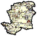
HANTSMAP PROJECT
The HANTSMAP project, 'Hampshire Cartulary', is exploring the
data available on old early county maps of Hampshire. Data on
these maps is being related to modern places; records of the
following pattern are beiing made:-
PLACE_IDENTITY Nether Wallop parish
IDENTIFICATION
PLACE_NAME Nether Wallop
OTHER_NAME Wallop, Nether & Wallops, The
PLACE Nether Wallop & Hampshire
LOCALITY_TYPE parish
PLACE_NAME NETH
TYPE4 library code
COORDINATES SU3036
TYPE4 centre
SOURCE
REFNO3 HANTSLOC.t
EVIDENCE
NATURE old map
PLACE_NAME Nethterwallop
PLACE
HUNDRED Thornegate
COUNTY Hamshire
LOCALITY_TYPE settlement & village
COORDINATES SU33
TYPE4 imposed
DATE 1595=1607 (?)
PERIOD 16th century & 17th century
SOURCE
OBJECT_NAME map
ID_NO HMCMS:FA1996.22
REFNO3 NORDEN1
EVIDENCE
NATURE old map
PLACE_NAME Neitherwallop
PLACE
HUNDRED Thorngate
COUNTY Hampshire
LOCALITY_TYPE settlement & village
COORDINATES SU33
TYPE4 imposed
DATE 1695=1701 (?)
PERIOD 17th century & 18th century, early
SOURCE
OBJECT_NAME map
ID_NO HMCMS:FA1996.33
REFNO3 MORDEN2
EVIDENCE
NATURE old map
PLACE_NAME Lowr. Wallop
PLACE
HUNDRED Thorngate
COUNTY Hampshire
LOCALITY_TYPE settlement & village
COORDINATES SU33
TYPE4 imposed
DATE 1788
PERIOD 18th century, late
SOURCE
OBJECT_NAME map
ID_NO HMCMS:FA1996.34
REFNO3 HARRIS1
RECORDER:DATE MN: 11.12.1997
The historical information is added to data loaded from the
termlist used for Hampshire localities: HANTSLOC.t. The
data, so far, taken from three old county maps of 16th-18th
centuries each with their spelling of the place name. The
imposed ngr is explained in the HANTSMAP project notes; it is an
indexing tool for the old maps.
A hundred might have a record like:-
PLACE_IDENTITY Thorngate Hundred
IDENTIFICATION
PLACE_NAME Thorngate
PLACE
COUNTY Hampshire
LOCALITY_TYPE hundred
COORDINATES SU21 & SU22 & SU23 & SU24 & SU32 & SU33
TYPE4 area
EVIDENCE
NATURE old map
PLACE_NAME Thornegate
PLACE
COUNTY Hamshire
LOCALITY_TYPE hundred
DATE 1595=1607 (?)
PERIOD 16th century & 17th century
SOURCE
OBJECT_NAME map
ID_NO HMCMS:FA1996.22
REFNO3 NORDEN1
EVIDENCE
NATURE old map
PLACE_NAME Thorngate
PLACE
COUNTY Hampshire
LOCALITY_TYPE hundred
DATE 1695=1701 (?)
PERIOD 17th century & 18th century, early
SOURCE
OBJECT_NAME map
ID_NO HMCMS:FA1996.33
REFNO3 MORDEN2
EVIDENCE
NATURE old map
PLACE_NAME Thorngate
PLACE
COUNTY Hampshire
LOCALITY_TYPE hundred
DATE 1788
PERIOD 18th century, late
SOURCE
OBJECT_NAME map
ID_NO HMCMS:FA1996.34
REFNO3 HARRIS1
RECORDER:DATE MN: 10.12.1997
Rivers should be recorded. A simple record could have
coordinates to find one end, the lower end has been chosen, then
- as an extra - a list of parishes through or by which it flows,
and a note of its relationship to the next river 'down':-
PLACE_IDENTITY Pillhill Brook
IDENTIFICATION
PLACE_NAME Pillhill Brook
PLACE
PARISH Upper Clatford
COUNTY Hampshire
LOCALITY_TYPE river
COORDINATES SU3544
PLACE
PARISH Abbotts Ann
PARISH Monxton
PARISH Amport
PARISH Thruxton
PARISH Fyfield
COUNTY Hampshire
RELNSHIP tributary to: Anton, River
Plotting data could be included in Mapping group as shown above.
PLACE_IDENTITY
Miscellaneous thoughts about Place identity data, which must be
a unique identifier for the record.
NB do remember that the Place identity is just a record
identifier: it is NOT the definitive Place name for the record.
Serial number A 'content free' serial number,
patterns:-
[serial no]
[prefix][serial no]
etc. A prefic might be useful to keep
particular sequences together, or have other
manangement uses.
A useful prefix in our database might be:-
Parish code+serial number
eg: ABB103
While this would group records within a
parish together (which could otherwise be
done from the recorded data anyway) it would
set up a tricky situation for control of
allocation of the numbers
Source+serial number
eg: Kelly 1907.123
or: GOSD1907.123 which has been used by IE
to mean the same thing 'GOSD' refering to
Kelly's 1907 directory of Gosport
NGR ... plus 10Km square reference could be used as a
prefix, eg:-
SU28
for a recording describing a 10Km square
This could have additions for various
purposes, eg:-
ST73 IA104
for iron age site no 104 within the 10Km
square
ST73 42 19 82
for data about 'spot' ST74183292, a
10x10metre square
Quadrat biological record system, eg:-
SU47D
for a record about a 2x2km square. Again,
add a serial number for records of areas
within the quadrat
Place name+modifier
Use the 'definitive' place name, or a
version; without a modifier there will be
repetition, place names are not unique
So, for Nether Wallop, use:-
Ashton Common, Steeple Ashton
Prefer the straightforward place name
(Alternative forms, eg inversions etc, can
and should be recorded within the record)
There will be special rules to cope with
repetitive names, for churches, rivers, ...
Parish/Locality, subplace
It may be useful to group some records under
a place name, parish or locality for which
there is already a record. For example
nameless localities within a place, or
perhaps streets within a locality, eg:-
Ampfield, pound
Alton, High Street, 3
If any historical research is used there will be a need to invent
records for places that might never have existed. These could
be signalled by a question mark in the Place identity, eg:-
PLACE_IDENTITY Turton Magna? Sweetcote
and might be supported by Note data justifying the invention,
eg:-
IDENTIFICATION
...
NOTE cf Turton Lane, and Turton Magna Farm,
...
HANTSLOC Rules
Place identity will generally be on the pattern:-
[Place name], [Parish]
eg:-
Holybourne, Alton
Titchfield, Fareham
The Place name is the definitive name for the place, this is
described elsewhere. NB the 'parish' used is the civil parish,
or pseudo parish where this is necesary; see OFR file PLACE.trm.
This pattern is used as consistently as possible. Long parish
names are not abbreviated, so that cross referencing is not
compromised by differences in data. The long record identifiers
that might be produced are accepted, eg:-
Harbridge, Ellingham, Harbridge and Ibsley
Note that the first comma is likely, but not guaranteed, to be
the separator between Place name and Parish, but there might be
further commas which are part of the data, not separators.
Rule Modifications
The general rule is not always apt. The parish term is not used
when the place recorded is the same, eg:-
Alton
When the parish is recorded the word 'Parish' is attached, eg:-
Alton Parish
making a separate record. Parish records for parishes outside
Hampshire will have their county name as detail, eg:-
Verwood Parish (Dorset)
If the place is conjectural, we do not know it exists, but are
inferring this from other information, a question mark might
beused, eg:-
St Clair's? Denmead
If the parish is not known you may record with an indication of
this, eg:-
Ashley Squires, ()
but more effort should be made to locate the place!
A place that is unrecognised, from an old map, caan be located
on that map by its hundred, eg:-
Tertiodean, Titchfield Hundred
Rivers
Some 'places' need to abandon the parish modifier rule. For
instance rivers are too extensive; the only parishes that would
make any sense are that where the river rises or that where it
loses its identity into a bigger stream. Generally use the river
name alone, eg:-
Stour, River
Inversion is more useful than not. Duplicate river names need
explicit rules for each instance; if this can follow some sort
of common practice so much the better, eg:-
Avon, Salisbury
for that river which runs through Salisbury as different from the
Bath Avon, or whatever.
A single record could be made about a river. Additional records
could be made to describe stretches of the river. It is probably
better to do this in a disciplined manner; recording chunks
parish by parish seems the best (but untested) idea. In this
caes the parish term will be added into the Place identity,
making a series of records, eg:-
Wallop Brook
Wallop Brook, Nether Wallop
Wallop Brook, Over Wallop
...
The chances of these records being in the right order is about
zero! So maybe another idea could be tried - but I prefer to
keep to an existing pattern.
Routes and Roads
Similar rules could be used for recording routes, eg:-
Ogilby Route 25
and roads, eg:-
Portway, The
The Ogilby routes are those depicted by John Ogilby in his route
maps, 1675. The number is the plate number from his road book.
Subdivision of these routes into segments could use his distances
from London, or parishes as before. The distances have the
advantage of sensible ordering.
The Portway could be subdivided by parish: but remove the ', The'
when adding the Parish.
Forests
Forests are very large areas which cannot sensibly have a
Parish; woods are smaller and should, eg:-
Chute Forest
Lower Wood, Ashmansworth
Administrative Areas
Administrative areas that are larger than a parish will not have
the parish term. This rule particularly applies to hundreds,
districts, county, etc. Examples:-
Alton Hundred
Basingstoke Borough
Hampshire
The word 'Hundred', 'District', 'Borough', etc should be attached
to the Place name, but it is thought unnecessary to use 'County'.
Churches
The dedication of the church will be used, with the Locality or
Parish, eg:--
St Mary, Alton
Use the church's Locality if this is known, else use the civil
parish - not the ecclesiastical parish.
Unknown
Places which have no known name could be recorded as:-
Unknown, [Parish]
Possibly adding a serial number to the first element if needed,
eg:-
Unknown [no], [Parish]
EVIDENCE.NATURE
Nature field in Evidence group is being used in the HANTSLOC
gazetteer to declare what type of ewvidence is being recorded.
the termlist for this field is:-
old map Data taken from an old map, eg Saxton,
Norden, Ogilby, etc.
description Description of the place from an old
geography or journal or whatever, eg
Camden, Leland, Cobbett.
archaeology Data coming from sitefinds or single
finds. This may well be generated from
Object Records of sitefinds groups or
single finds.
place name Place name explanations.
coat of arms Descriptions of coats of arms, seals,
etc.
domesday Data from Domesday survey, via various
sources.
These terms might be used to group data for output.
NGR DATA SETS
There are various ways a set of ngr coordinates, for a boundary,
contour, or other extensive place feature, could be stored.
CAD Drawing The data could be stored as a CAD
drawing. CAD is needed to 'see' the
coordinate data anyway, so this is an
obvious storage protocol. CAD data is
not accessible except in CAD; the
numeric values cannot just be read from
a list, nor can they easily be
manipulated except within the CAD
environment, with only whatever
procedures the CAD software provides.
It is possible to get the numeric data
out in .dxf form (which is a nightmare
to read) and to do calculations on the
data there.
DXF File The 'master' copy of the coordinate data
could be stored as a .dxf file; output
from a CAD drawing or generated by other
means. Data in this form is very
portable, in theory. In practice there
are differences between .dxf formats for
different CAD software that make
portability unreliable. The format is
horrible to understand, very
inefficient, and needs to be loaded into
CAD to be seen. Some image software can
read a .dxf file and convert to raster,
making a useable image file; the quality
of this conversion is sometimes poor.
DXF data looks like, following a
complicated header, a series of entries
like:-
POLYLINE
8
1
62
4
70
0
66
1
40
0
41
0
0
VERTEX
8
1
10
390.7
20
156.8
0
VERTEXT
...
SEQEND
MCR File Some CAD software can make and use a
macro file, imitating what would have
been done within the CAD program to make
the drawing. In AutoSketch this is an
.mcr file. It would be possible to
store coordinate data as an .mcr file;
the file has a simple and reasonably
efficient structure which can be
generated from other sources and then
used in CAD. The data is fairly
readable but has to be loaded into
exactly the right CAD software to be
seen.
Eg:-
"Menu","Polyline"
POINT 390.7,150.8
POINT ...
ASCII Text Coordinate data could be stored as an
ascii text file, marked up with tags in
some way to make the data 'useable'.
The data is comprehensible and safe, but
has to be edited into a .dxf or a macro
file before loading into CAD; it has to
be loaded into CAD to be seen.
Eg:-
@by
ST907568
...
MPLUS DATA The PLACE Format can store coordinate
data in a MODES file. The data storage
is compatible with all our other museum
data and is easily understood, if a bit
unreadable if there is a lot (the same
applies to any data set). MODES can
output the data to .dxf or a macro, or
whatever, with a little help from MMAGIC
software which is already written; the
data has to be loaded into CAD to be
seen. Data storage is not inefficient.
BUT - In the use of Mapping group
described above, note that each segment
of line is intended to stand alone as
a 'polyline' in a CAD drawing. Drawing
each segment separately they must join
end to end properly; this demands that
data at the end of one segment must
equal data at the start of the next (and
is recorded twice). Recorded data for
a boundary might belong in two separate
records, it could initially be copied
from one to the other. The data will
be very difficult to manage; it will be
difficult to maintain integrity.
Relational Tables It may be far better to store mapping
data outside MODES; and a relational
database management system will probably
be the best idea. It is likely that a
future MODES, networked, in Windows,
will be able to use such data.
Terminology Control
It may be possible to generate terminlogy control files (OFR
termlists or MODES .vln files) from the database. To facilitate
this it is necessary to include a note of what field in a MODES
format the definitive place data found in Item name field,
belongs in. A suggested pattern of recording is:-
IDENTIFICATION
PLACE_NAME Alton
TYPE3 Place term
PLACE
...
LOCALITY_TYPE parish
which defines 'Alton' as a valid parish term to go in a keyword
list in Place field. In this database the other Type3 term used,
so far, is 'Site name term'.