

report by Edmund Dummer and Thomas Wiltshaw
drape cartouche

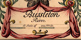
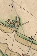
The map has a cartouche of red drapes, with branches of leaves, held up by an eagle, bottom centre.
Bussleton RiverThe cartouche also holds:-
scale
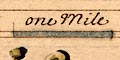
A Scale of one MileThe 1 mile = 72.4mm assuming a statute mile is 1 to 22229 or assuming a sea mile of 6082.95 ft is 1 to 25608. The map scale is about:-
1 to 22000 or 1 to 26000
3 or 2.5 inches to 1 mile
compass rose
up is N

There is a compass rose in the sea W of the river mouth. It has arrow points for the cardinal and half cardinal points, coloured red, pink, grey, blue, with a yellow fleur de lys marking north. The map is orientated roughly up is north.
foreshore
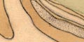
The sea is plain and uncoloured.
The foreshore area is coloured a sandy brown. An area east from the river mouth has what could be a bank of shingle on the upper foreshore. There is an inlet, almost a lake, in the foreshore east side at the mouth.

The coast line is pretty flat. An area on the E side of the estuary, about 2 miles in, is drawn with low ?rocky cliffs. There is another low cliff about 3 miles up on the W side. The landward area is tinted pale green.
ferries
The Hamble river mouth is the subject of the map. A small creek on the west side, 2.5 miles in, is drawn through the foreshore and a little inland. This seems to be the small stream that runs down from the area named Lowford.
The ferry at Bursledon is labelled by letter:-
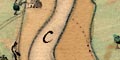
c - Bussleton Ferry
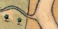
hillocks

The land area is modelled with low hills, shaded to the east, with a tree or two on each. The drawing of the spit on the E of the river mouth suggest a lower lying area, tinted a paler green (almost layer colouring!)
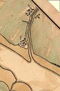
Woods are shown by groups of trees at settlements, and elsewhere. There are occasional trees about the land, tinted emerald green.
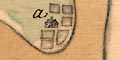
b - HambleAnother can be identified by being adjacent to:-
c - Bussleton FerryA hamlet on the E side of the river mouth is not labelled. On Milne's map, 1791, this is Hook.
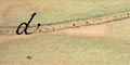
d - Road to Southamptondrawn by a double line from a tiny hamlet NE of Bursledon, on the river bank, by the ferry, through Bursledon, and off to the west towards Netley. This road continues east as a single dotted line across the foreshore, crosses by the ferry, is drawn as a single dotted line along the opposite foreshore to a house opposite Burseldon, where it become a double dotted line off to the ESE towards Fareham, labelled:-
e - Road to Portsmouth
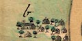
a - Salt Pansdrawn as a series of rectangular ponds, with a house. These salterns were still visible on Milne's map, 1791, on Hamble Common.
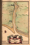
Collins 1693
Dummer 1698
Click images to enlarge
Dummer and Wiltshaw's chart of Bursledon has details not shown in the chart by Greenvile Collins.
report by Edmund Dummer and Thomas Wiltshaw